It was supposed to be a Day of Fun.
We were planning to throw our blankets down at Scarborough beach, drink some sort of summery orange-infused beer, soak up the sun, and relish in our last few days of freedom before work starts again. But after an interminable string of 90-degree days, the temperature suddenly dropped. It didn’t look like it’d even break 70 degrees until the afternoon, and why go to the beach wearing layers?
“Have you heard of Arcadia?” my friend M-Dogg asked. “Not Acadia,” he clarified.
Acadia, without the “r,” is the national park in Maine I just visited for the first time when Steven and my parents were here. Some know it as “the Cyprus of the US,” and it was indeed beautiful. Here’s a photo of my mom, Steven, and me, remarkably not getting lost on a hike in Acadia.

But Arcadia is in Rhode Island, and I’d ironically just seen a sign for it a few days prior, when driving north from Connecticut. I didn’t know what it was, but I knew it existed near Exeter, RI.
“I’ve seen people post photos from there,” M-Dogg continued. “There are trails and lakes…it seems pretty. Want to check it out?”
And so, to commemorate seven years of friendship, we loaded up on bug spray and headed south.
The first place we stopped was a parking area with a sign for a lake. They had a porta-potty, which I found instrumental to our hike. But based on some Google searches and the “all trails” website, the trailhead that we wanted–for a 6.7 mile hike–was in a different spot. We plugged the coordinates into GPS and behold: only nine minutes away, off of Highway 165. We were off to a great start.

M-Dogg parked right next to the trailhead, in what we assumed was a safe-to-park place, but couldn’t tell for sure. It was a small inlet from the highway, not big enough for more than two cars, but we didn’t see anyone fighting us for a spot. A sign near the entrance warned us: Danger! Eastern Equine Encephalitis. I didn’t know what “EEE” (as M-Dogg called it) was*, but I loaded up on another round of mosquito repellant just in case.
*I just looked it up, and I’m glad I didn’t know.
The trail we followed had yellow and blue blazes, and they were easy to follow, though compared to Acadia, this trail was more…rugged. It was a well-worn trail in that the trail was obvious, but not so heavily trafficked that it was big enough for more than one person to walk through at a time. Grasses and other plants leaned in toward my exposed legs, tickled my ankles, and I immediately regretted wearing shorts and no-show socks.

More than once, M-Dogg said, “Oooh, watch out for the poison ivy,” which didn’t help. (I mean…it did help in a practical sense, but not in a mitigating-fear sense.) All I could think about was ticks and how my friend’s son recently contracted Lyme Disease.
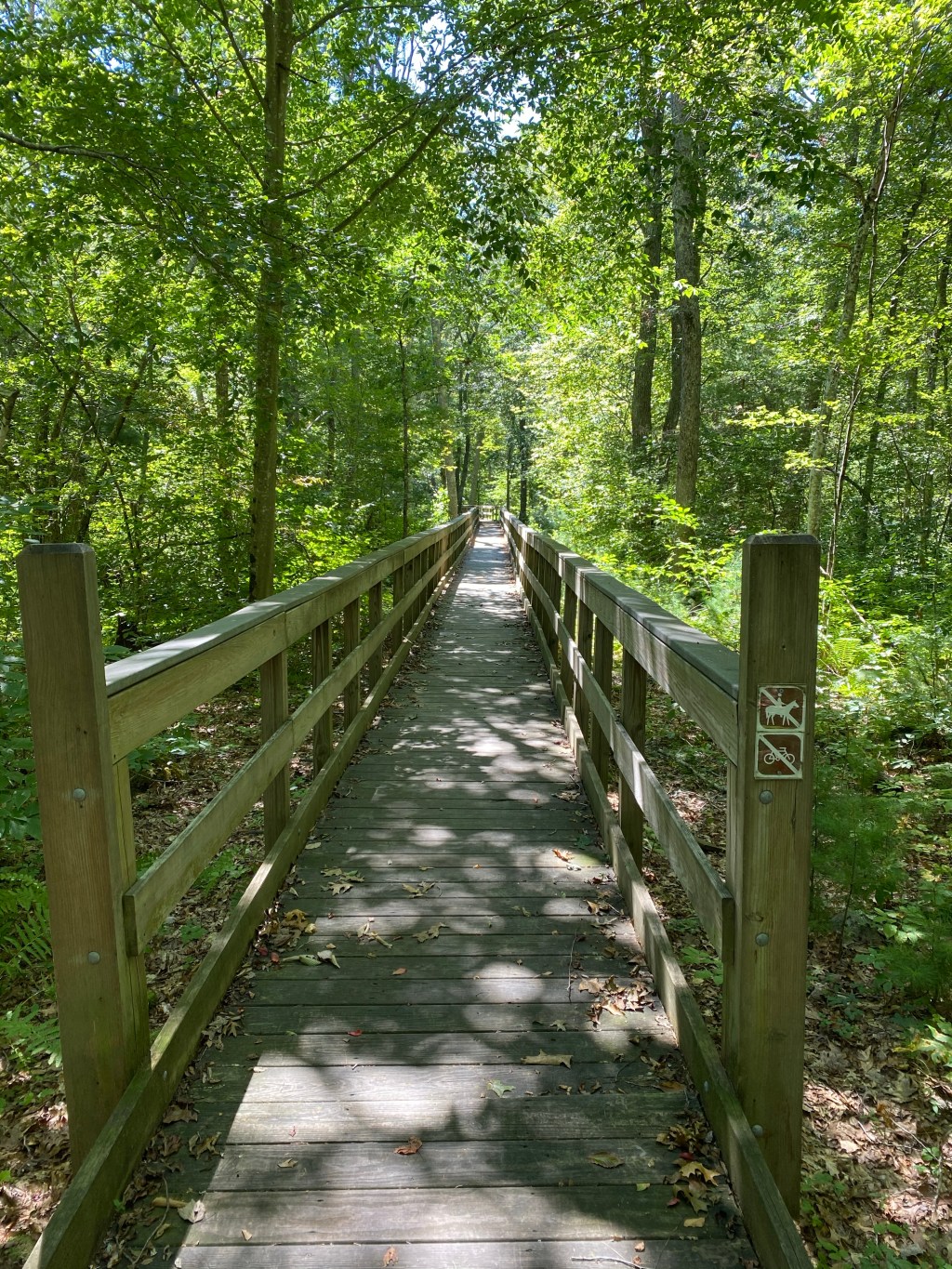
Nevertheless, the miles passed relatively quickly and easily–it was a flat trail, if nothing else–and soon we found ourselves at a clearing by a lake. Along the perimeter of the water was an elevated trail made of wood, like a foot bridge, and on it were outcroppings for benches or picnic tables. Ahead of us, two people were fishing. I checked FitBit and it said we’d walked 3 miles. We were right on track!
We stopped for a snack break. I brought nothing with me but a cell phone and water (I take after my father), but M-Dogg brought food, which he kindly shared. He ate a Kind bar (fitting), and I opted for a package of crackers that harkened to my elementary school days. We chewed in silence and beheld the view.

Then we were off again, this time on a safely elevated wooden walkway, away from disease-bearing plants and insects. We followed the trail around the perimeter of what we thought was a lake. It was picturesque and serene.

The perimeter walk abruptly came to a close.
“Was that the entire lake?” M-Dogg asked. “That seems more like a pond.”
I shrugged. We found ourselves on a packed dirt road, fitting for a car, and walked for a few minutes before M-Dogg said, “This doesn’t seem right. I thought we would only be on the road for a short distance. Hold on,” and he pulled out his phone to look at the trail map. He seemed puzzled. Then he looked at Google, to find our location.
“WHAT?!” he exclaimed.
“What happened?”
“How in the…” he shook his head. “Well, this is where we wanted to hike…”

Then he zoomed out. “This is where we are.”

“I mean, I’ve taken a wrong turn on a hike before,” M-Dogg said. “But I’ve never gone 180 degrees in the wrong direction.”
It really is impressive.
At this point, we had a choice to make. Do we continue following the yellow blazes and see where it went, or turn around and go the way we came, ensuring we find ourselves at the car, right where we started?
Follow the yellow blaze road, of course.
That worked for a while: we went to our left, our right, our left, and eventually we found ourselves at another semi-established road. There we hit a three-directional crossroad.
To our right, the yellow blaze. To our left, a fork. The road on the right of the fork seemed well-traveled; the other, less-traveled. M-Dogg checked Google maps again to see where we were in relationship to the car. If we followed the yellow blaze, the safe and intelligent choice, we’d be walking in the opposite direction from our car. If we took the well-traveled road, we’d be walking in the direction of our car, but come out on Highway 165 quite a distance away from where we’d parked. If we took the road less traveled (perhaps you see where I’m going with this), we would potentially lose the trail but be close to a different road that would deposit us near our car.
Yes, my friends. We took the road less traveled, and that has made all the difference.
“It’ll be an adventure!” I said, something M-Dogg was faithful to point out 45 minutes later when we were bushwhacking through the forest, but I’m getting ahead of myself.
At first it wasn’t too bad. We were on a partial trail through the undergrowth, which again made me wish I’d worn tall socks. And pants. There were many obtuse forks in the road that made it unclear which way to go (we’d lost the blazes when we decided to take the “adventurous” route). At one point we followed what seemed to be a mountain biking trail until we hit an impasse, and we decided to turn around and go the opposite direction on the fork, over a creek with wooden bridge (a manmade structure must count for something, right?)
We continued on, this time toward another creek in which there was no bridge. Exposed stones peaked through the water, which made it easy to cross, but it was still foreboding.
“We’ve gone too far to turn around, don’t you think?” M-Dogg asked. He consulted the map again. “See? The road is just right there,” he said, making his thumb and pointer finger only a centimeter apart.
I checked my watch. It did seem unreasonable to go all the way back to the three-way crossroad, then walk in a Lord-knows-how-long-of-a-loop until it turned us back around toward 165.
I shrugged. “We might as well keep going,” I said.
And that’s when we lost the trail.
At first I was worried primarily about ticks, and of course poison ivy, particularly when we came across an entire bed of it. Thankfully all of M-Dogg’s years in AmeriCorp (and hiking/camping generally) allowed him to spot it and point it out, otherwise I would have definitely strolled right through it.
Then there were the spiders.
")

THERE WERE SO MANY SPIDERWEBS! I squealed and squirmed when M-Dogg deconstructed one that was five feet across, and wept silently as I realized they were lurking all around me. There were spiderwebs on the undergrowth, holding leaves and debris together; there were spiderwebs in the plants and on branches, from tree-to-tree as we walked through them.
M-Dogg offered to go first with a large stick, to break the cobwebs, and at one point he let out an “AH!” and did a 360, swatting his arms.
Finally he stopped. “There’s not a spider on me, is there?” he asked, and turned around so I could look at his back.
At first, I didn’t see anything. And then:

A giant brown something-or-other clung to his backpack.
“Give me the stick!” I shouted.
He hesitated. “THE STICK, THE STICK! GIVE ME THE STICK!” I cried, and he handed it to me. I squealed again as I swatted the giant beast to the forest floor, then hurried over the spot where it landed.
About this time I decided to put on my long-sleeve shirt (at least I’d brought something helpful). This offered a false sense of security as I high-stepped like a giraffe, trying to avoid poison ivy, spiders, ticks, and all the other insect-infested bungalows of underbrush.
“You’re doing great!” M-Dogg said, then laughed when he saw my T-rex arms and high stepping technique.
“Are we getting close?” I asked.
M-Dogg looked his phone. “It says we’re, like, right there,” he said.
Google Maps is a liar, I learned that day.
Suddenly, I saw a trail marking: a red blaze on a tree.
“A trail!” I said.
Granted, the blaze was thick with red paint and dripped in the corners, as if intentionally meant to resemble the blood of a sacrificed being, but it was a trail nonetheless. We climbed over a fallen tree and felt a sense of hope!
Only that trail ended, too.
M-Dogg began telling stories to distract me, including the history of stone walls and what it means when you find them (someone’s farmland, maybe? I was only half-listening since I was maintaining constant vigilance), when not five minutes later we came across a stone wall.
We had the option to walk into the stone wall or enter a valley of ferns. There was no end in sight to the woods.
“Where is the road?” I wondered aloud. I may have whined.
The centimeter he’d made with his fingertips had been reduced to a millimeter, and yet we could see no road in any direction. We could hear cars in the distance, as if from the interstate, but nothing that seemed immediately helpful. In every direction, there were plants, plants, and more plants, and they were growing in size.

Then: another red blaze. The trail!
Then another fork in the road.
We went to the left. After walking some way, I could see the trail ended and there was a bunch of tall grass, so I asked M-Dogg to scope it out. Off he ran (yes, ran), through the grass and out of sight. I was alone for several minutes, my cell phone in M-Dogg’s backpack. I took a sip of water and thought, This is the perfect time for the serial killer to come out from his hiding place and take me to his underground den. Thankfully, M-Dogg was quick.
“No road,” he said. “Let’s go the other way.”
Finally, after more than an hour of bushwhacking and giraffe-stepping, we saw a house. A glimmer of hope. Civilization that might be connected to a road!

But it was eerily quiet.
The house was surrounded by the woods we had traversed, and M-Dogg was quick to point out there had been no signs for “Private Property.” But the slides and monkey bars and porch were empty with untouched toys. M-Dogg pointed to a car at the back of the property–a black sedan, with no tires and no doors–and said it was like a scene in the Goonies**, when the kids stumble across a crime family’s house.
We walked by a single swing hanging by large chains from a tree branch overhead, and to our right, still in the woods, was a giant white canvas tent, shaped like a shed, staked to the ground and tightly closed.
**I’ve never seen the Goonies. I was thinking more along the lines of Kiss the Girls or Deliverance.

“This is where sociopaths hide dead bodies,” I whispered, fully convinced we’d stumbled across a real crime family’s den.
We walked quietly from their “backyard” woods around the driveway and down the street, where other houses sat in eerie silence, chairs overturned in gardens, no one outside on this sunny, 70-degree day.
No one, that is, except for the dogs.
Only one house stood between us and Highway 165, and there were one…no, two?…no, three large, unleashed barking dogs on the lawn.
“Aw, they’re friendly!” M-Dogg said. “Look, that one’s wagging its tail.”
I am not so easily fooled.
Suddenly, a man appeared from the houses behind us. He was blonde and very pale, with thick lips and a slow, almost southern twang to his speech.
“Is there a problem?” he asked. “Are y’all okay?”
I picked up on that fake friendly way people ask nice questions and offer help, which really means why are you trespassing on my property?
M-Dogg was quick to tell him we were fine, we’d just been hiking in the woods and took a few wrong turns.
“I was gonna ask if you were lost,” the man said.
“We were lost,” I chimed in. “But we know where are now. Thanks.”
“Okay,” he said, looking back and forth between us, then told us the dogs were kept in by an invisible fence.
We turned away from him and, with feigned confidence, walked down the street past the dogs, who thankfully didn’t seem motivated enough to endure electrical shocks in order to kill us, and made it to the highway.

M-Dogg checked his phone.
“Oh no,” he said.
“What now?” I asked with dread.
“It says we’re two miles from the car.”
At that point, I was thankful to be on a real road–albeit one without a shoulder–and out of the woods and away from psychopaths, so I didn’t care about an extra 40-minute walk amid more grass, discarded wine bottles, while semi trucks whooshed past us. We were struck by kamikaze butterflies***, but in the end we made it, and M-Dogg’s car was STILL THERE! It occurred to us he may have parked illegally, and with the way our day was going, the car might have been towed.
***they literally pelted me in the arms, legs, and stomach. Maybe they were grasshoppers? Or locusts? Or demons?
We celebrated our (mis)adventurous day by drinking cocktails, eating pizza, and having cake.


(For all who are keeping score, we shared the pizza, but we each had our own cake.)
So, to M-Dogg: here’s to another year of friendship, adventures, days of fun, and near misses by spiders, ticks, and banjo-playing cannibals (or more realistically, very angry dogs).
Cheers!

Leave a comment